
Trace a Berkeley Street Address
A Berkeley Township street search works best as a record trail, not as a list of people. Start with a complete street address and use the county tax list to locate the assessment parcel. The parcel keys, especially municipality, block, lot, and qualifier when present, are stronger links than a street name alone. They can then be carried to the land-record index and compared with the map. The tax card can identify a property location and mailing fields, but neither field proves who currently lives there.
- Search the Ocean County Tax List Search with Berkeley Township selected and the most exact property location available. Record the block, lot, qualifier, and the source date.
- Open the Ocean County GIS hub and compare the parcel position with the county boundary and tax-map context. The interactive control labels and pop-up fields were not captured in the research, so record only fields actually displayed during a live search.
- Use the parcel keys, a party name, or an instrument date in the Ocean County Official Records Public Search. The free index begins April 1, 1977, and an index hit should be checked against the recorded instrument.
- For a defined election-record need, use the Ocean County Board of Elections request path rather than treating a street as a universal voter directory. The statutory list is organized by election district, street, and address, but it remains a voter record rather than a census.
- For older household clues, consult the library or historical-society directory holdings by year. A historical address entry is a lead that needs comparison with the dated property record.
That sequence keeps each source in its lane: tax records for assessment, GIS for parcel context, the Clerk for instruments, election records for the limited voter purpose, and directories for historical address clues.
Berkeley Street Directory Tax Fields
The county tax-list form provides the most clearly captured address-oriented field set for Berkeley Township. It does not label every possible result field as a search field, and the separate Berkeley WIPP tax portal was not captured closely enough to claim a particular control or output. Use the county form first when the object is a parcel, then preserve the spelling of the property location exactly as returned.
| Captured tax-list field | Form role | Street research use |
|---|---|---|
| Municipality | Selector | Select Berkeley Township instead of inferring jurisdiction from a mailing city or ZIP. |
| Block | Numeric or text entry | Primary parcel join for tax, GIS, and land-index research. |
| Lot | Numeric or text entry | Pairs with block to distinguish a parcel on the same street. |
| Qualifier | Optional entry | Distinguishes a special or condominium-style parcel record when the source supplies one. |
| Property class | Selector | Filters by the assessment class or use category. |
| Property location | Text address | Searches the situs or property location, while retaining the original street spelling. |
The captured form is the source for these labels. A blank field may broaden or narrow a query depending on validation, so avoid assuming a field is optional in every search state.
The official tax-list search form shows the Berkeley Township field arrangement.
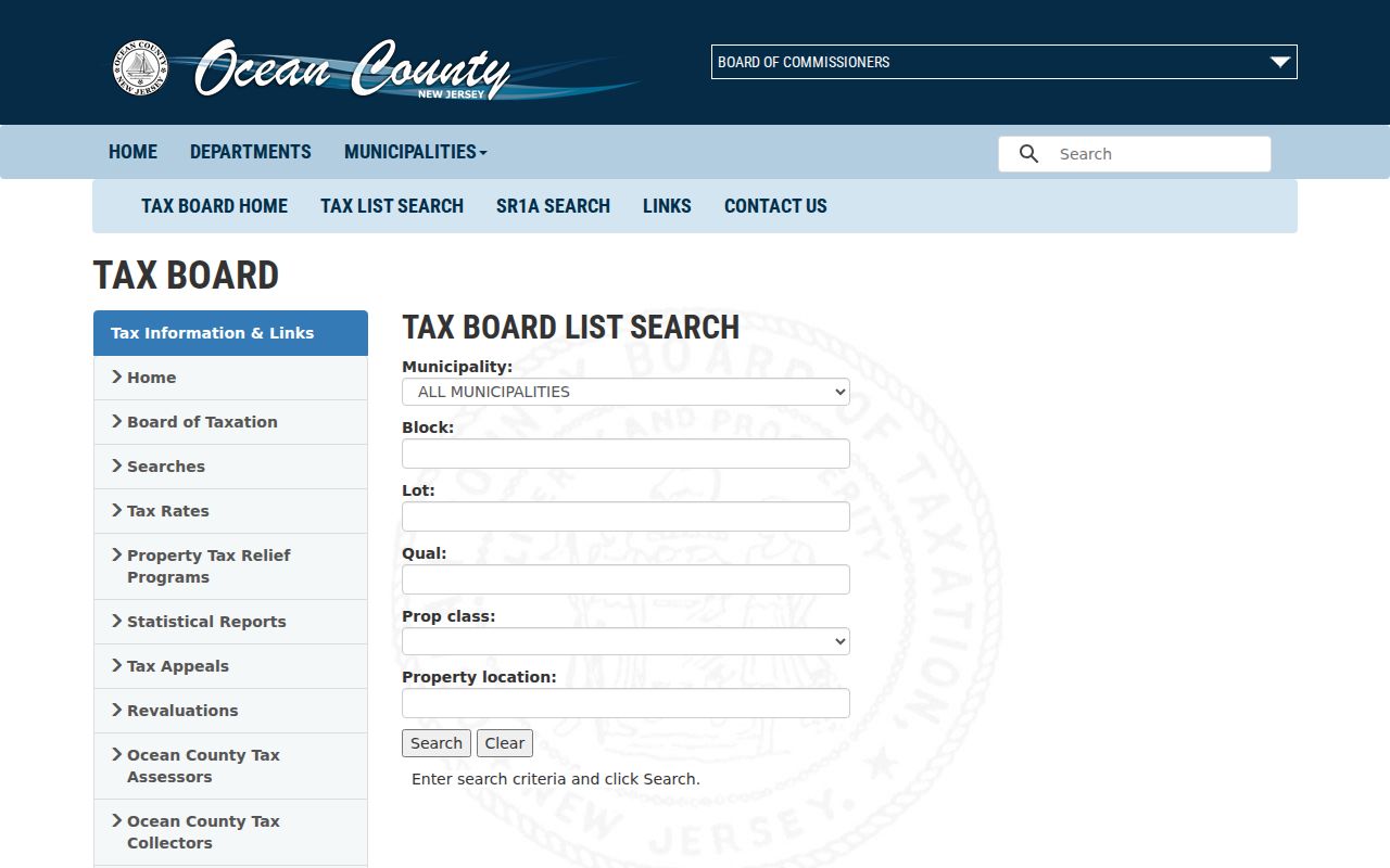
Those labels support a block-and-lot workflow, not a claim that the form identifies every resident connected with an address.
Berkeley Street Permit Routes
Construction information follows a dedicated route rather than a broad street-directory query. Berkeley Township’s OPRA instructions direct construction records to the SDL Portal and tax information to WIPP. That direction identifies the portal path, but the research did not capture SDL’s live search fields, public date range, result schema, or a Berkeley sample. Do not assume that every permit, inspection, code matter, owner field, or address history is searchable there.
When a portal does not answer a defined record question, identify the street address, block and lot if known, record type, department, and date range in a focused request. Berkeley’s online OPRA form offers email, on-site inspection, mail, and pick-up delivery choices, and its printable form is an alternate route. OPRA is a fallback for a specific municipal record, not a request to create a new address analysis or a substitute for the dedicated portal.
Berkeley Street GIS Layers
Ocean County’s GIS program supplies the spatial side of a street-directory search. The county lists municipal boundaries, parcel and cadastral information, easements and rights-of-way, aerial imagery, zoning, flood zones, tax maps, subdivisions, wetlands, streams, parks, and other planning layers. Its 2025 Parcel and MOD-IV geodatabase is a useful vintage marker when a current parcel, an older deed, and a mapped shape do not align.
Use the map to compare parcel geometry and nearby identifiers, then return to the tax list and Clerk index for record evidence. County guidance says the statewide composite parcel data are maintained by counties and are not legal surveys. The research confirmed the viewer entry point and layer categories, but did not capture the live ArcGIS pop-up schema or exact buttons. Do not invent layer names, identify-tool labels, or an owner field that a live session does not display.
Note: A GIS outline places a parcel on a map, while the tax record and recorded instrument establish different facts about that parcel.
Berkeley Parcel Detail by Street
A tax-board detail card can add useful structure after the street search returns a parcel. The documented sample schema includes municipality, block and lot, ZIP, property location, class or use, assessment history, physical characteristics, sale history, book and page, deed date, grantor and grantee, sale price, and record date. A mailing address and a property location can differ. Keep each as a separate field rather than replacing one with the other.
Some details describe an assessment or a sale-history display, not title. A sale entry may lead to a grantor or grantee, but current ownership requires checking the instrument chain. The County Clerk’s index is the appropriate follow-up for an instrument number, book/page reference, party, or date. Exact image-download and certified-copy pricing were not captured, so confirm the current copy route with the Clerk before requesting a record.
The official parcel-detail example documents the fields visible on a county tax-board card.
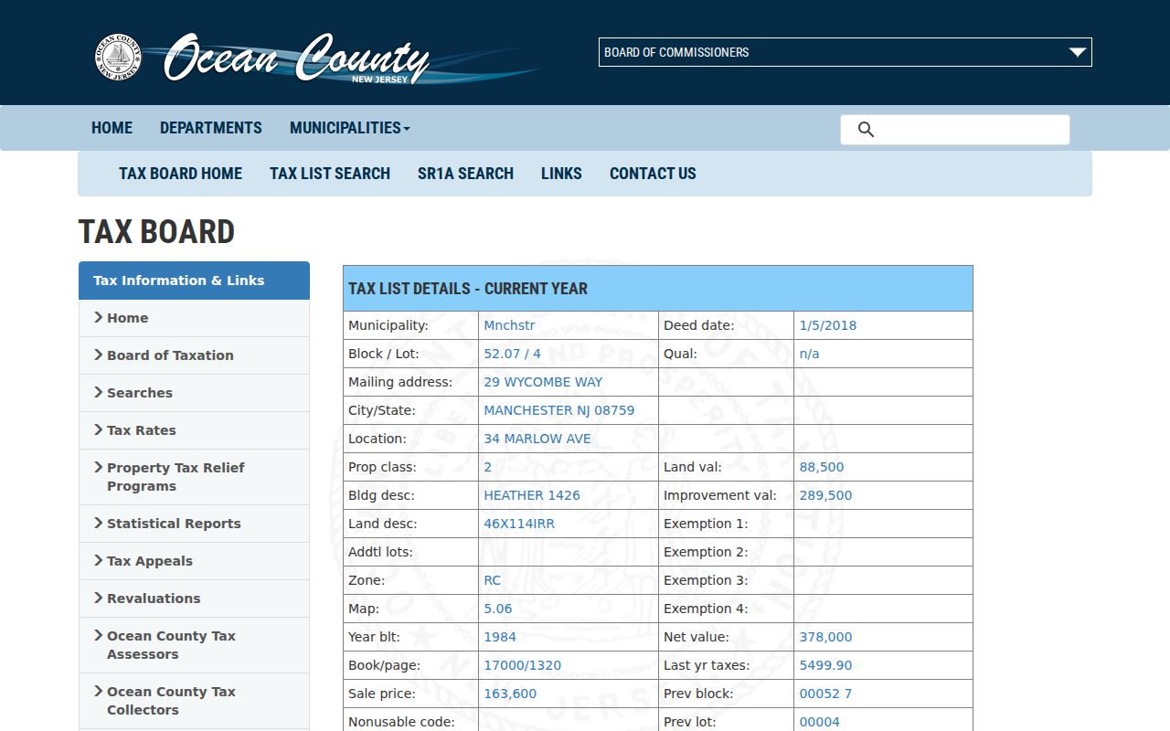
The example is a field schema, not an assertion about ownership or residence at the sample parcel.
Berkeley Street Deed Trail
The Ocean County Clerk’s public index lets an address-based search move from parcel identifiers to recorded instruments. It supports document type, town, consideration, date range, name or property search type, instrument number, book and page, block and lot, legal-description text, map and parcel identifiers. Search party names as “Last-Name First-Name” when using the index’s name guidance, and try supported spelling variations if a likely name is absent.
Index results can show type, instrument number, date, book/page, page count, consideration, map or parcel references, parties, and status fields. The site describes its public results as unofficial or watermarked. Treat the result as a way to find the document, then inspect or order the recorded instrument for a title question. An absent result does not rule out a pre-April 1, 1977 record, an alternate spelling, another county, or a protected field.
For an in-person or records-request path, the Ocean County Clerk is at 118 Washington Street in Toms River and lists 732-929-2018. The Clerk’s public search, office route, and OPRA channel serve different access needs, especially when a web index does not settle a document question.
Berkeley Street Directory Records
No single record set answers who is connected with every address on a Berkeley Township street. This street directory view keeps each address-keyed source distinct. A tax card can identify a parcel and assessment fields. A deed index records an instrument and parties. A voter-file request is limited by election law and access rules. Historical directories can supply dated household clues. Combining them without labels can turn an old address or a mailing field into an unsupported claim.
| Address-keyed source | Custodian | What it can establish | Documented access routes |
|---|---|---|---|
| Tax-list and parcel detail | Ocean County Board of Taxation | Assessment parcel, situs or mailing fields, characteristics, and sale-history references | Public tax search; Berkeley Assessor and county office for defined questions; specific records request when needed |
| Parcel and tax-map layers | Ocean County GIS | Parcel context, boundaries, tax-map and planning layers | ArcGIS hub, county downloads, planning-office contact, and tax-map or Clerk joins if a map field is unavailable |
| Recorded instruments | Ocean County Clerk | Documented transfers, liens, mortgages, parties, book/page, and dates | Free public index, Clerk office, Clerk OPRA route, and older-record research through the State Archives |
| Voter registration or history file | Ocean County Board of Elections | Public statutory voter fields organized by election district, street, and address | Registration-check link for an individual status route; signed OPRA and Election Order by fax or mail for a comprehensive defined file |
| Historical directories and phone books | Ocean County Library and OCHS | Dated address and household leads | Catalog or in-branch research, Wheeler Room materials, and OCHS in-person or remote research service |
The state voter registration page links the individual registration-check service, but its live form returned 403 during this research. A failed text capture is a channel problem, not a finding about a person. For a defined county file, the Elections request instructions require a signed form by fax or mail, and a comprehensive voter list requires both an Election Order and OPRA request. The county generally states 7 to 10 working days, with possible election-cycle delay.
Berkeley Street Notice Lists
Berkeley Township’s certified mailing-list application is a narrow but valuable street research tool. It requests owners within 200 feet of a selected block and lot for a notice purpose. The application records the block, lot or lots, zone, site address, street name, property-owner information, and applicant information. It is not a list of everyone who lives nearby, and it should not be treated as one.
The documented fee is $10 per block/lot, with a stated seven-business-day processing time. The form can be submitted in person or by email. Use it when the need is the official owner-notice universe for a particular parcel, then compare returned names with the current tax list and recorded instruments. For a request outside that product, Berkeley’s OPRA form asks for a specific record description, preferred delivery, and the relevant department, date range, or parcel key.
This is a research-driven numbers point: the fee and timing apply to the certified notice list, not to a broad street search.
Berkeley Street Record Terms
Address sources use similar words for different things. Keeping the terms separate helps retain an original source entry without losing the modern parcel key.
- Parcel
- A mapped property unit used by the tax and GIS systems. Its boundary or identifier is not, by itself, proof of current title or residence.
- Situs address
- The property’s physical location or street address. It can differ from the tax mailing address.
- Plat or tax map
- A mapped depiction of lots and boundaries used for land and assessment context. It is not a legal survey unless the source says so.
- Block, lot, and qualifier
- The parcel identifiers used to join Berkeley assessment research with Ocean County tax, GIS, and Clerk records.
- Criss-cross directory
- A historical reverse-style directory that may lead from a street address to a dated household entry. It is a historical clue, not a current roster.
Preserve the source’s original street line, its municipality or city line, ZIP, parcel identifiers, and date. That small evidence packet is more useful than a name copied without context.
Berkeley Street ZIP Checks
Bayville is commonly the postal city for Berkeley Township, but a ZIP is delivery geography rather than a municipal boundary. A Berkeley parcel can carry Bayville 08721, Toms River-area 08757, or another documented delivery ZIP. The safer address check is the full street address, followed by municipality, block, lot, and parcel ID. Keep the original city line in a source note rather than rewriting it to fit a guessed jurisdiction.
Use USPS for exact-address and ZIP+4 confirmation, the tax list for the parcel record, and GIS for municipal context. The county municipal directory can help distinguish a municipality from a mailing city, but it is not an address-level USPS database. The related Berkeley Township ZIP code directory keeps the delivery-area cautions together when a street search crosses a postal boundary.
Berkeley Street Transition Dates
Street and parcel searches near South Seaside Park need a source date. Berkeley Township’s March 31, 2026 transition notice describes the recent annexation context, while a related tax notice says South Seaside Park property taxes remained payable to Berkeley through December 31, 2026 and that collection changes take effect January 1, 2027. A current mailing line, municipal status, tax collector, and tax-map version may therefore not all point to the same administrative moment.
Record the agency name and date shown on each result. That approach also helps with older addresses, because Berkeley was formed from Dover Township in 1875 and later boundary changes created several successor municipalities. An older deed or directory may use a jurisdiction that is not the current parcel municipality.
Berkeley Street Record Limits
A street search cannot establish every household connection. Tax mailing fields may point somewhere other than the parcel. A deed grantee may not be the current owner, and a voter record is not a complete resident directory. Private utility records, MVC address information, protected substitute addresses, and restricted court material are not public street-search tools. New Jersey’s Address Confidentiality Program and Daniel’s Law can also cause an address to be absent or redacted.
Lawful use. Berkeley Township street and parcel records are for personal, lawful research and should be handled with care. Never use address information to stalk, harass, intimidate, or harm another person.
When a result is missing, note the source and access limit instead of trying to reconstruct a protected address. The most defensible outcome is often a dated record reference, not a claim about where a person is now.